
House and yards 1884
Quick links on this page
The Anglo-Saxon years 1065
Domesday Book 1086
Gatesbury's Manor 1235
First OS map 1836
RAF Chedburgh arrives 1942
Foot of page 2015
|
History of
Gatesbury's Farm, Stansfield and latterly Depden
From a small medieval manor to a modern farm
(Click on any illustration to see a larger version)
|

Risbridge Hundred
|
|
1065
|
The origin of the administrative units known as "Hundreds" is largely unknown and may well have grown up at different times depending upon location in the country. It is usually suggested that they are sub-divisions of the shire counties. However, in East Anglia, it may well be the case that the Hundreds were in place before the region was divided into Norfolk and Suffolk. This division probably occurred under the Danish King Canute in or about 1021, after the Earl of East Anglia, Thorkell the Tall, was exiled, and Canute wanted to strengthen his own hold over that area.
The Hundreds may well have existed in the 10th century, and were thought to have been set up as taxation units, based upon the value of one hundred hides. Each hide represented the living that could be derived from an average holding of 120 acres. The much older "vills" were basically spatial units, representing an area of land holding under a single Lord, whereas Hundreds were value units, set up by the national fiscal authority.
The farm now known as Gatesbury's was located in Risbridge Hundred, in the vill of Stansfield, later to be called the parish of Stansfield. Gatesbury's was located at the extreme north-west of Stansfield, and was always much closer geographically to Depden than to Stansfield's main settlement.
The map of Risbridge in 1086, shown here, includes the modern county boundary shown as red dashes. From this we can see that Exning and Newmarket were in Cambridgeshire in 1086, while parts of modern Haverhill were in Essex in 1086.
Each Hundred had its own court under the Hundred Bailiff, second only to the County or Shire Court. They dealt with folk rights, and might be called "Things" or "Moots". These met at long established open air meeting places originally set up by the early Anglo- Saxons, probably before the Hundreds were established. These meeting places were held at well known landscape features, such as meres, fords, prominent mounds, or important boundary markers.
The old meeting place names seem to have been used to name the Hundreds, and even as late as 1894, many of the Hundred names were still significant enough to be inherited by the newly established Rural District Councils. A few names even survived the 1974 reorganisation of local government, notably Babergh District Council, but with a different geographical area.
Although the names remained constant, the boundaries were in flux throughout the lives of the Hundreds. Even by the time of the Domesday Survey in 1086, it was clear that changes in lordships or land values had resulted in a much less than clear picture of the overall patterns of control.
|
|

Stansfield and adjacent parishes
|
|
blank |
This map gives a close up view of Stansfield and its adjacent parishes of Deden, Wickhambrook, Denston, Poslingford and Hawkedon, in the Hundred of Risbridge. Gatesbury's Farm is located within the area where Stansfield sits next door to Depden.
The Domesday Book of 1086 concentrates upon lordship and feudal relationships since the Norman Conquest. However, in some places it also gives the names of the Saxon Lords who had held their lands in the years before 1066. Examples from Stansfield are as follows:- -
One estate of 75 acres now in the hands of the Abbot of St Edmunds had belonged to 7 unnamed freemen before 1066.
-
A carucate of land now in the hands of Count Roger Gilbert de Clare belonged to an unnamed socman.
- Two carucates of land had been held by the Saxon Edric Spucla, but by 1086 belonged to Count Gilbert.
-
Another carucate of land had been held by the freeman Ulflet, who had Robert over him by 1086.
-
A block of 60 acres had belonged to the freeman Crow, but by 1086 he also had Roger placed over him.
Note:- One carucate is regarded as 120 fiscal acres.
At present it is not possible to relate any of these lands to the manor which became known as Gatesbury's.
|
|
1086
|
Stansfield was a settlement recorded in Domesday Book, in the hundred of Risbridge and the county of Suffolk.
It had a recorded population of 16 households in 1086, and is listed under 3 owners in Domesday Book.
The landholder number and land parcel number used in the Phillimore edition of the Domesday Book for Suffolk have been retained as an aid to cross referencing to that written text.
The translated entries shown are also deliberately laid out differently from the original for clarity. The original entries were in one continous line of text, and contained many abbreviations, which are shown here in extended and translated form. It is possible that some abbreviations have been mistaken by modern translators in one or two places.
Most of our modern day villages have entries in Domesday, but do not equate exactly to modern boundaries. Contemporaries might have recognised these as names of "vills", rather than villages. A vill might roughly coincide with our own ideas of a parish area, rather than just the built up part of the village sharing the parish name.
All the Domesday entries for Stansfield are gathered here in one place, but in the original Domesday Book the holdings were described under each landholder.
SUF 14, 155
Lands of the Abbey of St Edmunds
Overlord in 1066: (Bury) St Edmunds, abbey of.
Lord in 1066: free men, seven.
Households: 7 freemen.
Annual value to lord: 11 shillings and 2 pence in 1086.
SUF 25, 11
Land of Richard son of (Count) Gilbert
Lord in 1086: Roger.
Lord in 1066: Wihtgar (son of Aelfric).
Households: 1 freeman. 2 smallholders.
Ploughland: 1 men's plough teams.
Other resources: Meadow 3 acres.
Livestock in 1066: 3 cobs. 4 cattle. 7 pigs. 40 sheep.
Livestock in 1086: 3 cobs. 6 cattle. 30 pigs. 80 sheep.
Annual value to lord: 1 pound 10 shillings in 1086; 1 pound in 1066.
SUF 25, 78
Land of Richard son of (Count) Gilbert
Tenant-in-chief in 1086: Richard son of (Count) Gilbert.
Lords in 1086: Gilbert; Robert; Roger.
Overlord in 1066: Wihtgar (son of Aelfric).
Lords in 1066: Crawa; Edric Spud; Wulffled.
Households: 2 smallholders. 4 slaves.
Meadow 10 acres. 1 mill. 1 church. 0.12 church lands.
Livestock in 1066: 4 sheep.
Livestock in 1086: 14 cattle. 25 pigs. 80 sheep
Annual value to lord: 5 pounds 5 shillings in 1086; 3 pounds 10 shillings in 1066.
Richard FitzGilbert held 170 lordships in Suffolk and Essex which soon became known as the Honour of Clare. An "Honour" was a collection of manors held by one landlord.
The early development and administration of these lay estates was complex. Richard fitzGilbert (or of Clare as Domesday occasionally refers to him, LDB 389v) advanced rapidly in William's service and probably gained his Suffolk lands after helping the king to suppress the Earls' Rebellion of 1075. By 1086 his demesne manors were valued at over £400, together with subinfeudated land at £185. The most valuable manors were kept under his direct control, although they were probably leased rather than exploited directly. The largest example was Hundon, which at 25 carucates was the highest rated, and therefore probably the largest manor in Suffolk (a carucate is 120 fiscal acres).
|
|

W A Copinger Manors of Suffolk
|
|
1235
|
Walter Arthur Copinger FSA FRSA (14 April 1847 – 13 March 1910) was an English professor of law, antiquary and bibliographer. In 1902 he issued the History of the Parish of Buxhall, of which he was lord of the manor. For our purposes his published work entitled "The Manors of Suffolk" in 7 volumes is the most useful. Volume 5 covered the Hundreds of Lothingland, Plomesgate and Risbridge, published in 1909.
He noted that he published only details from existing sources.
He found three manors in Stansfield:-
- Stansfield Manor
- Gatesburies or Catesbye's Manor
- Manor of Priditon Hall - Probably later known as Purton Hall
His first reference to Gatesbury's was headed, "Gatesburies or Catesbye's Manor". In 1235 Richard de Muntfichet had the fee, and it passed to his daughter Margaret, who married Walter de Bolebee.
|
|
1262
|
Gatesbury's had passed to Walter and Margaret's son and heir, Hugh de Bolebee. Hugh died in 1262 leaving four daughters.
-
Philippa de Bolbee married Roger de Lancaster
- Margery married Nicholas de Corbet followed by William de Grimesthorpe
-
Alice married Walter de Huntercombe
- Matilda married Hugh de la Val
|
|

Site of Priditon Manor
|
|
1275
|
Meanwhile the nearby manor of Priditon Hall was held in 1275 by Walter de Priditon, passing later to Sir Roger de Priditon.
|
|
1317
|
In 1317 Copinger found that Priditon Hall manor was owned by the Gatesbury or Salisbury family. This was evidenced by a fine levied by Adam, son of Richard de Gatisbury against one Richard de Gatisbury. Priditon Hall now becomes part of Gatesbury's manor.
|
|
1319
|
The first link with Catesby's Manor seems to be in 1319 when Richard de Gatesbury received a grant of free warren here.
|
|
1420
|
John de Gatesbury held the manor we know today as Gatesbury's. He seems to have left two daughters and co-heirs, one married to Henry Elvedon of Ivy Mountjoy in Essex. The other daughter was married to John Lavingham of Gatesbury in Hertfordshire.
|
|
1454
|
There is further evidence of a fine of the Priditon manor levied on John Jolker and his wife, (among others) one of the heirs of Adam de Gatesbury.
|
|
1506
|
In 1506 Gatesbury's was vested in Sir Robert Broughton. Upon his death in 1506 it passed to his son, Sir John Broughton. This included the lands of Priditon Manor.
|
|
1558
|
Gatesbury passed down the family until the death of Alice, the wife of John, Lord Russell, in 1558.
|
|
1706
|
In 1706 the manor was in the hands of Sir Edward Atkins.
|
|
1770
|
Gatesbury's was now held by John Mayor or Moore, of Kentwell Hall, who passed it to Charles Bigg.
|
|
1795
|
Charles Bigg now passed it to Bateman Bigg.
|
|

OS one inch map extract 1836
|
|
1836
|
In 1836 the Ordnance Survey published its first one inch map showing Gatesbury's Farm. On the map it is labelled as "Gainsburys", a pronounciation still used by local people into the mid 20th century.
|
|
1844
|
In White's Directory of Suffolk dated 1844 John Pratt is listed as the owner of Purton Hall. John Foreman is listed as the bailiff at Gatesbury.
|
|
1855
|
In White's Directory of Suffolk for 1855 John Pratt and Richard Pratt are farmers at Purton Green. John Woods is a farmer at Gatesbury (and Moulton).
|
|

Bristol Estate buys Gatesbury's
|
|
1874
|
Gatesbury's Farm, in Stansfield and 270 acres 1 rod and 39 perches in Stansfield, Depden, Rede and Wickhambrook was bought by the Bristol Trustees from James Bunbury Blake and George Pilkington Blake.
|
|
1892
|
In White's Directory of Suffolk for 1892 Mr Richard Pratt is at Purton Green, noted without a trade or profession.
|
|
1900
|
In Kelly's Directory of Suffolk for 1900 only Charles Webb is noted as a farmer and landowner in Stansfield.
|
|
1916
|
In Kelly's Directory of Suffolk for 1916 Benjamin B Marsh is listed as a farmer at Gatesbury. John Marsh is a farmer at Stansfield Hall.
|
|
1926
|
In Kelly's Directory of Suffolk for 1926-1926 Benjamin B Marsh is listed as a farmer at Gatesbury.
|
|
 Squadron website.")
RAF Chedburgh from the air 1945
|
|
1942
|
In 1941 and 1942 John Laing Construction arrived in Chedburgh to begin construction of a new single squadron RAF Bomber station. The general elevation here was 410 feet (125 metres) above sea level. Three concrete runways were laid down, together with ancillary buildings.
Being a bomber station Chedburgh would have three runways made of concrete, the initial construction being one of 2,000 yards and two of 1,400 yards, all the standard 50 yards wide, as was the standard specification, class A, brought in during 1941. Later on, these would be extended giving Chedburgh much longer runways than many of its counterparts, one extended to 3,000 yards and two at 2,000 yards. Having runways this long, meant that heavy bombers could use the site when in trouble.
RAF Chedburgh was completed in September 1942 as a second satellite for RAF Stradishall and 214 Squadron arrived in October and flew the Short Stirling bomber until late 1943. Part of the 214 Squadron was split off as a nucleus for the new 620 Squadron in Summer 1943. They moved to Leicester East in November 1943 when 1653 Conversion Unit formed to become a Stirling training unit at Chedburgh.
1653 Conversion Unit stayed until December 1944 when they left for North Luffenham. It was replaced by 218 (Gold Coast) Squadron on the 5th December flying Lancasters as part of 3 Group's bomber offensive. They also dropped food in the relief of Holland but disbanded on 10th August 1945.
In September 1945 Polish Squadrons 301 and 304 arrived with Warwicks and some Wellingtons flying transports, mainly to the Middle East.
Halifaxes arrived in 1946 for 301 and 304 and were used on trunk routes overseas until December 1946.
RAF Chedburgh was now closed in December, 1946. It had been home to 1,600 RAF personnel and 240 WAAFs. Their accomodation huts are now removed as are the 36 hardstandings.
The site was sold in 1952 and what was the technical area of the RAF station is now a light industrial estate where use can be made of buildings and hardstandings. The remainder is agricultural once again.
|
|
1946
|
In 1946 the Wreathall family became the latest tenants of Gatesbury's Farm. Hugh Wreathall recalled that it was normal for the local farmhands to refer to the farm as "Gansburys", a dialect pronounciation that was also used in the first 1836 Ordnance Survey one inch map.
He also recalled that at Christmas it had been normal for turkeys to be driven to Bury market from Clare up through Purton Green, along the ancient trackway to Gatesbury's farm and thence to the Bury Road. This old trackway was also shown clearly on the 1836 OS map.
Meanwhile it seems that the buildings of the technical site of the RAF station were taken over by a small farmer called Mr Fred Blower, from Cornwall. He kept dairy cattle in some nissen huts, pigs in the MT Store, chickens in air raid shelters and Aylesbury ducks enjoyed the static water tank. He also kept hives of bees and lived in the office of the Flare Path Party. Apparently he paid rates but no rent.
Presumably Mr Blower or Blewitt lost his home when the site was sold in 1952.
British Pathe News have a short film about this farmer which can be found here:
The derelict Aerodrome Farm Chedburgh August 1950
|
|
1954
|
In 1954 the Wreathall family bought Gatesbury's farm from the Bristol Estates. They had been tenants since 1946. There was no electricity supply to the farm at this time and it was a period of changeover from horses to machinery. The farm had just been equipped with a combine harvester.
|
|

Parish boundary change
|
|
1959
|
By this time the trackway from Clare to Stansfield and Purton Green and onwards to Gatesbury's farm and so to Bury St Edmunds was largely neglected. The main Havehill to Bury road had long been tarmacadamised and suitable for the newer motorised transport. The new road by-passed Gatesbury's leaving the farm isolated at the end of a single track country lane from Depden.
This caused the farm to become much easier to access via Depden, and more isolated from Stansfield.
At some point, thought to be in the late 1950s, Gatesbury Farm was given a revised address when the boundary of Depden parish was moved to include that farmstead. The farm's association with the parish of Stansfield was now ended after perhaps 1,000 years.
This map shows the new locations of both parish boundaries around the farmhouse and yards. The solid green line shows the original boundary of Stansfield. The red dotted line shows the modern parish boundary incorporating Gatesbury's Farm into Depden parish. Click on the thumbnail to see a wider view showing the Haverhill to Bury road with a solid red line.
|
|

Phone mast 2008
|
|
2008
|
Because of its relatively elevated position for Suffolk, at over 400 feet above sea level the GPO has situated a phone mast with microwave dishes at a point they call Great Wood Hill, just off Gatesbury Lane.
|
|

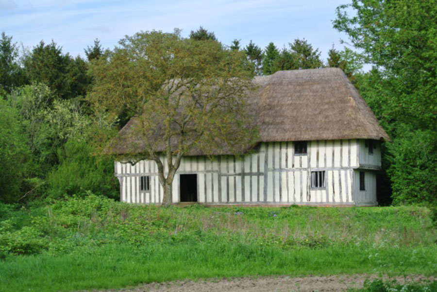
Farmhouse in 2008
|
|
blank |
The original farmhouse is seen here in 2008.
The main barn had just finished being converted into two dwellings for family use or for rental purposes.
|
|

Old trackway to Purton Green
|
|
blank |
The route to Purton Green from Gatesbury's is shown here. It is now just a track between fields, used only by a few hardy walkers and farm machinery.
|
|

Hugh Wreathall in 2012
|
|
2012
|
In 2012 Hugh Wreathall was interviewed for the East Anglian Daily Times, to speak about the diamond jubilee 60 years of the Queen's reign. Mr Wreathall, who bought the farm along with his father and brothers in 1954, having been tenants since 1946, says the mixed arable family farm, which his son George now runs, is doing well, despite the inevitable ups and downs of the last six decades.
“We’re high cold and heavy out here near Bury St Edmunds, so we’re limited to what we can do,” he says. “But we have a good rotation and produce wheat, beans, rape and barley in the main. The farm will take every shilling you throw at it.”
|
|

Airfield taxiways still visible
|
|
2015
|
The attached "Mapcarta" map shows very well the still remaining outline of RAF Chedburgh's taxi ways around the airfield. These remain as farm tracks today, and the concrete remaining is suitable for vehicle parking and farm storage areas.
|
|
Quick links on this page
Top of Page 1065
Domesday Book 1086
Gatesbury's Manor 1235
First OS map 1836
RAF Chedburgh arrives 1942
Airfield outline today 2015
|
Prepared for this St Edmundsbury website
by David Addy, 15th June, 2023
Books and other resources consulted:
British Pathe film of the aerodrome at https://www.britishpathe.com/asset/81034/
Above film clip Issued August 1950. 1minute 53 seconds
"RAF Chedburgh 1942-1946" Published 1995 by Chedbugh Memorial Trust.
Website, https://aviationtrails.wordpress.com/2018/01/10/raf-chedburgh-an-appalling-loss-of-life/
https://218squadron.wordpress.com/raf-chedburgh/
https://mapcarta.com/N3428782671
Suffolk Record Office, Bury St Edmunds
| |


 Squadron website.")


